Distributed Fibre Sensing
DAS, DTS and candidate DSS provide route-scale, spatially continuous observation through the primary ultra-light fibre infrastructure.
IMBAK Dynamic Canopy Research & Intelligence Network a drone-first, dynamic, retrievable and relocatable scientific infrastructure designed for continuous rainforest understanding with minimum necessary ecological presence.
In plain words: a drone maps the forest and lays an ultra-light fibre-optic infrastructure for DAS, DTS, DSS and Distributed Fibre Sensing. Where fibre cannot adequately provide a research-defined measurement, a small number of retrievable Autonomous LoRa Scientific Pods may provide specialised point sensing without creating new terrestrial gateway infrastructure inside the protected forest.
IDRCIN combines reconnaissance drones, LiDAR/RGB mapping, a Temporal Digital Twin, ultra-light fibre infrastructure, DAS / DTS / DSS, selective autonomous point sensing, scientific data acquisition, local validation, NeuralOps Detached Systems, controlled retrieval and rotational redeployment.
Sensor placement, fibre deployment, inspection and retrieval are designed to avoid routine human presence beneath the canopy unless science, ecology or safety requires it.
The sensing layer is temporary and relocatable rather than a fixed permanent grid. Research cycles can move between zones as scientific questions evolve.
Raw evidence remains preserved while validation, indicators, alerts and projections are versioned, traceable and researcher-governed.
Imbak Canyon is positioned here as one of Sabah’s most important pristine rainforest conservation and research landscapes. IDRCIN is designed to strengthen an existing research ecosystem not to turn the forest into a technology showcase.
One shared field backbone can support multiple research programmes microclimate, biodiversity, hydrology, atmospheric studies, vegetation, canopy dynamics and other researcher-defined campaigns.
Wireless availability does not equal ecological permission. If fibre or remote sensing is adequate, scientific value is low, or disturbance is disproportionate, the correct engineering decision is not to deploy.
The proposal compares real alternatives: no physical monitoring, conventional field monitoring, permanent infrastructure and dynamic drone-deployed monitoring.
| Approach | Routine Human Presence | Technology Presence | Continuous Data | Spatial Flexibility | Main Concern |
|---|---|---|---|---|---|
| No Physical Monitoring | Very Low | None | Low | N/A | Information gap |
| Conventional Field Monitoring | Medium–High | Low | Low–Medium | High | Repeated access |
| Permanent Monitoring | Low after installation | Persistent | High | Low | Permanent footprint |
| IDRCIN | Low | Temporary / Relocatable | Continuous fibre; research-cadence point records | High | Drone, fibre, batteries, electronics and wildlife interaction |
Set limits for sensor and pod count, fibre length, battery and enclosure mass, drone missions, hover duration, human entry, maintenance, retrieval success and deployment period.
Is the information required? Is this the lowest reasonable intervention? Can the hardware be retrieved? Can impact be measured? Does the benefit justify presence?
IDRCIN is positioned against the alternatives it replaces. The table below is indicative and meant to be budgeted against real site data before commitment.
| Dimension | IDRCIN | Manual Field Monitoring |
|---|---|---|
| Routine human presence | Low drone-deployed | High repeated access |
| Data continuity | Continuous, distributed | Episodic |
| Physical footprint | Temporary, relocatable | Persistent stations |
| Carbon from access | Lower fewer human trips | Higher fuel & travel |
| Energy source | Fibre terminal / DAQ power plus sensor-specific pod batteries; harvesting only where validated | Battery / grid dependent |
The observatory layer runs deterministic validation and routing on-premise. Only prepared, minimal context reaches AI reasoning, reducing unnecessary transfer, model calls and token use.
Heavy reasoning is optional and on-demand, not a constant background load. This keeps carbon proportional to use rather than idling large models continuously.
Illustrative preliminary estimates, subject to validation. Physical layer: Manual ≈ 1.84 t CO₂e/yr vs IDRCIN ≈ 0.56 t CO₂e/yr (≈70% lower operational field emissions). Digital layer: Full-AI 32B tokens vs NeuralOps 2.5B tokens (≈92% lower variable AI workload; ≈64.5% lower estimated whole-system compute footprint). Figures are scenario estimates not audited lifecycle data and should be replaced with measured vehicle km, fuel, drone kWh, mission count and compute tokens during the POC.
IDRCIN uses a Fibre-First Architecture. Distributed fibre remains primary; an Autonomous Specialised Point-Sensing Layer is supplementary and permitted only where fibre cannot adequately provide the required measurement.
DAS, DTS and candidate DSS provide route-scale, spatially continuous observation through the primary ultra-light fibre infrastructure.
A small number of independent pods measure specialised soil, water, vegetation or atmospheric properties only at approved points.
Reconnaissance uses LiDAR/RGB and spatial context before any physical placement. Routing combines physical, ecological and engineering maps. AI proposes; human reviewers approve.
Canopy geometry, terrain, waterways, gaps, obstacles and structural context.
Sensitive habitat, control plots, nesting areas, conservation restrictions and researcher-defined no-go zones.
Drone clearance, fibre route feasibility, abrasion risk, pod retrieval probability, terrain / canopy RF constraints, receiver geometry and mission safety.
The integrated spool stores the continuous fibre, provides distance-controlled payout, and contains the built-in quick release. The mechanical load is carried by a dedicated support tether not by the fibre optic line.
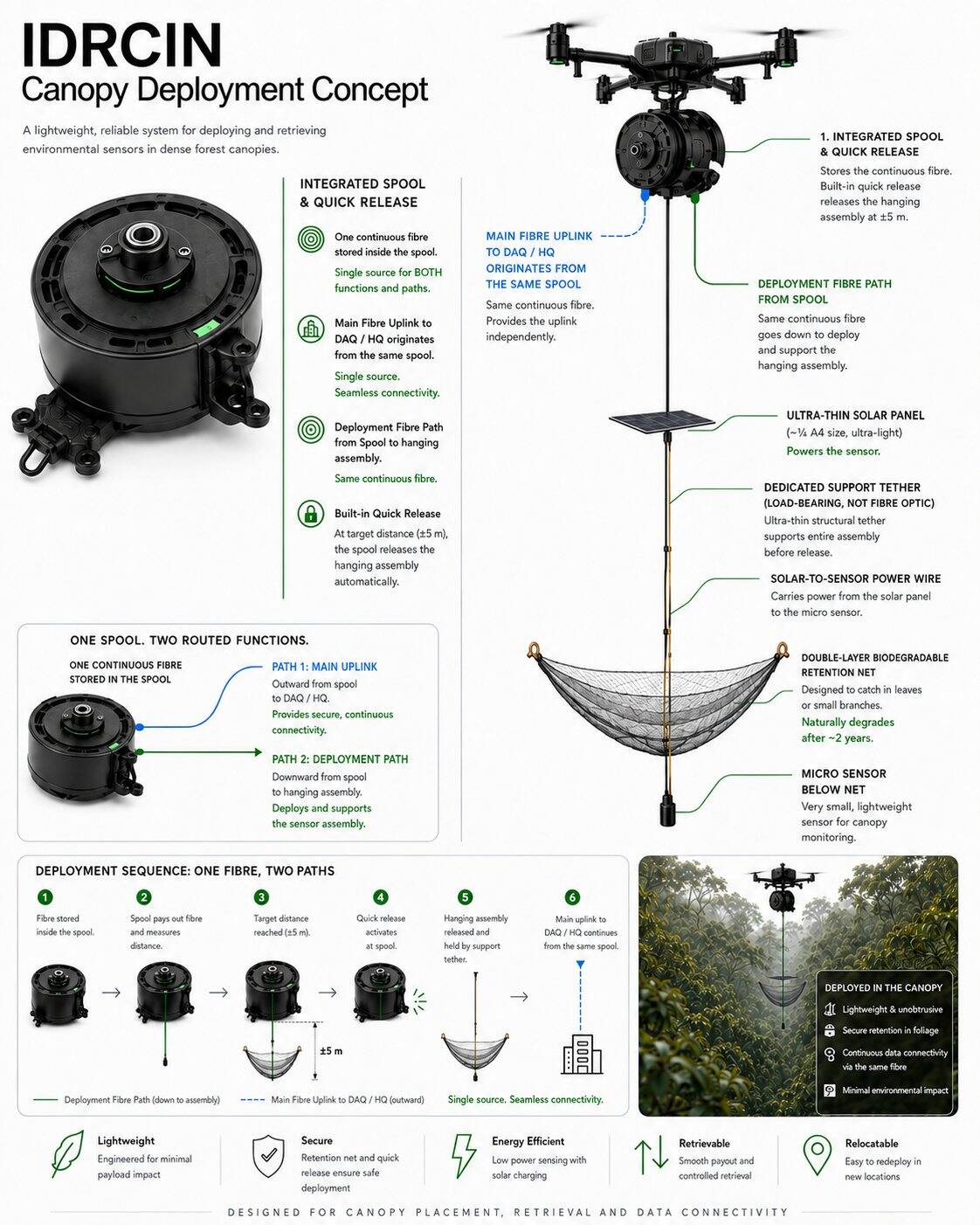
The DAQ/HQ uplink originates from the same spool. It is not routed from the sensor, solar panel or retention net.
The illustrated hanging assembly applies to the fibre-connected endpoint concept. It does not define the independent Autonomous LoRa Scientific Pod architecture.
Autonomous pods use sensor-specific batteries and power management. Solar harvesting is optional and requires ecological, irradiance and field validation.
Every measurement point has a clear spatial identity. For the autonomous layer: one specialised sensor maps to one Autonomous Scientific Pod. Redundancy comes from distribution, not permanent multi-sensor stations.
No unnecessary edge database or heavy compute. A bounded non-volatile scientific buffer, watchdog and power controls are required; interpretation remains at the observatory layer.
Microclimate, atmospheric/carbon, vegetation, biodiversity, acoustic, hydrology and other measurements are selected by researchers not dictated by the platform.
The Autonomous Specialised Point-Sensing Layer is a supplementary, delay-tolerant scientific instrument layer. It is not a generic IoT network and does not replace Distributed Fibre Sensing.
Battery → Power Management → Deep Sleep / Scheduled Wake. Battery capacity is determined by measured sampling, storage, successful and failed radio-attempt energy, environmental derating and the approved retrieval cycle. No service-life guarantee is assumed.
Radio activity is bounded by research cadence, health state, payload value, energy reserve and lawful airtime. Pods do not continuously transmit.
Retain timestamped records, prepare periodic summaries when scheduled, then return to deep sleep.
Transmit a compact authenticated payload within retry and energy limits, then return to sleep. High-volume raw data remains local or uses the appropriate fibre / retrieval path.
No new in-forest gateway, relay, mesh infrastructure, wireless tower, communications hut or permanent repeater station is proposed.
Local buffering and bounded direct communication attempts. No pod-to-pod mesh and no permanent relay chain.
May be considered at an existing authorised observatory or approved location only where technically feasible and where link budget permits.
Candidate classes are drawn from the existing research philosophy. Every selection still requires study methodology, model selection, calibration, power, maintenance, ecological and deployment approval.
| Measurement | Why Fibre Is Insufficient | Proposed Sensor Class | Sampling Behaviour | Payload | Maintenance Concern | Research Value | Status |
|---|---|---|---|---|---|---|---|
| Soil moisture / temperature | Canopy fibre does not directly measure a defined soil depth or volumetric water content. | TDR / FDR / approved soil probe | Periodic, event-aware | Scalar reading + quality flags | Contact, drift, installation disturbance | Rewetting, drought and slope response | CANDIDATE |
| Soil pH / EC / oxygen / redox | Requires direct chemical or electrochemical contact. | Study-specific chemistry probe | Periodic with stabilisation | Scalar + temperature compensation | Calibration, fouling, sealing | Soil chemistry and aeration | SUBJECT TO VALIDATION |
| Water level / groundwater | Requires local stage, pressure or distance reference. | Pressure, radar or ultrasonic level sensor | Periodic; event summary | Level, temperature, health | Datum, compensation, flood damage | Hydrology and flash-flood context | PILOT |
| Turbidity / pH / conductivity / DO | Requires an immersed optical or electrochemical probe. | Water-quality probe | Periodic with cleaning checks | Scalar values + quality flags | Biofouling, drift, corrosion | Water-quality change | SUBJECT TO VALIDATION |
| Leaf wetness / point RH / pressure | Requires a local reference surface or atmospheric point. | Low-power microclimate probe | Periodic; threshold summary | Compact scalar batch | Shielding, orientation, contamination | Microclimate and wetness cycles | CANDIDATE |
| Tree tilt / stem growth / sap flow | Requires direct tree-level physical or physiological instrumentation. | Inclinometer, dendrometer or approved sap-flow probe | Low-rate trend / event features | Trend, event, health | Attachment, species method, calibration | Tree mechanics and water stress | PILOT |
| Selected ecological probe | Research-specific direct observation may not be available from fibre. | Approved low-payload specialist instrument | Research-defined | Feature / event, not assumed raw stream | Method, power, wildlife interaction | Defined only by approved study | SUBJECT TO VALIDATION |
The 60 research programmes are not 60 hardware systems. Applicability is classified conceptually as Fibre Only, Autonomous Point Sensor, Hybrid, or Remote Sensing / No Additional Physical Sensor.
| Scientific Need | Primary Mode | Reason |
|---|---|---|
| DAS / vibration / route disturbance / tree-fall-related event candidates | FIBRE ONLY or FIBRE + UAV validation | Distributed mechanical streams belong on fibre; raw high-rate data is not routine LoRa payload. |
| DTS / distributed temperature | FIBRE ONLY | Route-scale optical temperature profile, subject to calibration and environmental context. |
| DSS / distributed strain | FIBRE ONLY · PILOT VALIDATION | Requires compatible cable, coupling and interrogator validation. |
| Soil, water chemistry, hydrology, leaf wetness, selected atmosphere, tree mechanics | AUTONOMOUS POINT SENSOR | Requires a specialised physical probe at a selected point. |
| Storm, thermal stress or water-stress context | HYBRID | Combines distributed fibre evidence with approved local reference measurements. |
| LiDAR, photogrammetry, canopy gaps and derived indicators | REMOTE SENSING / NO ADDITIONAL PHYSICAL SENSOR | Use UAV or existing upstream streams; do not create duplicate pods for derived variables. |
Scientific zones are logical research areas, not gateway sites. Fibre streams and pod records received through existing / approved infrastructure feed deterministic acquisition, local storage and NeuralOps Detached Systems for cross-zone validation and authorised synchronisation.
Validation on receipt, missing-data and sequence checks, timestamp and clock checks, drift detection, threshold analysis and system-health monitoring.
Primary field storage, cross-zone context, synchronisation, network management and resilience when cloud links are unavailable.
Long-term storage, Temporal Digital Twin, delayed-data reconciliation, analytics, projection, APIs, collaboration and secure researcher access.
IDRCIN separates scientific evidence from processing outputs and advisory projections while supporting delayed, duplicated, retransmitted and physically recovered pod records.
Every critical rule can have an ID, version, owner, parameters, threshold and validation status. Pod data adds device ID, boot / sequence number, timestamp quality, checksum, calibration version, retry state and delivery provenance.
Timestamped records are persisted before transmission. Bounded retries preserve energy and unsent records remain available until acknowledgement, capacity limits or retrieval.
Device identity, boot identifier and monotonic sequence number support at-least-once delivery with deterministic deduplication.
Last-known-good reading, clock quality, memory health and explicit loss markers prevent communication silence from being mistaken for environmental absence.
Repeated reconnaissance versions canopy geometry, gaps, storm damage, sensor locations, fibre routes and research zones. Autonomous pods also become georeferenced instrumentation objects tracked over time.
Initial LiDAR/RGB and ecological baseline before deployment.
T6M, T12M and later scans support longitudinal context around natural and system-related changes.
Use repeated observation to assess visible disturbance and improve deployment design after each cycle.
Projection can combine received near-real-time fibre data, delayed pod records, accumulated history, seasonal behaviour, cross-zone correlation and researcher-defined indicators.
Investigate a developing condition before a critical threshold is reached.
Unexpected patterns can guide the next research question and the next sensor deployment.
Inspection missions and researcher attention can be prioritised based on evidence and confidence.
The recovery reel is treated as a controlled mechanical system. Abnormal tension should trigger stop-and-inspect behaviour rather than increased pulling force.
STOP → INSPECT → DECIDE
Research cycles can operate for six or twelve months, then retrieve, inspect, reconcile local records, calibrate and relocate the sensing layer to answer a new question.
Collect continuous distributed measurements.
Identify anomalies or meaningful patterns.
Form a new research hypothesis.
Move instrumentation to test the next question.
Compare cycles and improve methodology.
LoRa does not remove battery, probe, enclosure, antenna, calibration or retrieval obligations. It remains selective specifically because every electronic point introduces additional failure modes.
Use battery trend, sensor drift, memory state, clock quality, resets, last contact and enclosure indicators to prioritise approved intervention rather than routine inspection.
Calibration, fouling control, reference comparison and uncertainty review remain sensor-specific. Communications health does not prove measurement quality.
Track deployed, retrieved, replaced, lost and decommissioned pods, batteries, antennas and mounts. No electronic unit is treated as disposable.
Potential impacts include drone noise, rotor wash, fibre interaction, bird collision, wildlife curiosity, branch friction, pod enclosures, antennas, battery material, electronic waste, lost units and retrieval disturbance. None are dismissed by design rhetoric.
Visibility treatments may reduce accidental collision but must be field-tested because different fauna may respond differently. Avoid claims of automatic bird safety.
Small footprint, low-duty electronics and reuse may reduce permanent stations and routine access, but batteries, electronics, wildlife interaction and failed retrieval remain explicit liabilities.
The proposal treats strengths and opportunities together with their limitations and response strategies.
The initial risk model covers ecological, engineering, data, AI, connectivity, regulatory and governance failure modes.
| Risk | Cause | Impact | Detection | Mitigation | Fallback |
|---|---|---|---|---|---|
| Battery depletion | Sampling load, retries, leakage, degradation | Sampling stops | Battery trend, brownout and reset telemetry | Measured power budget, retry cap, safe mode | Planned retrieval |
| Moisture ingress / corrosion | Seal failure, condensation, material exposure | Failure or invalid readings | Enclosure indicator, current anomaly, inspection | Environmental tests, replaceable seals, material control | Retrieve, contain and replace |
| Antenna damage | Wildlife, branches, deployment impact | Communication loss | Signal trend and inspection | Low-profile protected geometry | Local storage and retrieval |
| Canopy attenuation / terrain shadowing | Wet vegetation, ridge, valley or slope obstruction | Delayed or absent delivery | Link tests, RSSI / SNR, backlog age | Site-specific modelling and field margin | Approved alternate bearer or retrieval |
| Satellite visibility | Insufficient sky view, service window or compatible terminal | No NTN delivery, energy waste | Contact and acquisition-energy logs | Attended tests, bounded attempts, operator validation | Direct approved receiver or retrieval |
| Sensor drift / probe fouling | Ageing, contamination, biofilm | Biased science | Reference checks, drift rules, calibration status | Sensor-specific cleaning and calibration | Exclude interval or use manual reference |
| Lost pod / failed retrieval | Mount failure, flood, access or location error | Litter, data loss, ecological liability | Asset register and missed retrieval status | Retrieval scoring, durable ID, approved windows | Authority-led recovery decision |
| Wildlife interaction | Shape, smell, movement, mounting | Harm or equipment loss | Inspection and permitted observation | Wildlife-safe design and site review | Relocate or stop deployment |
| Clock drift | RTC drift, reset, unavailable reference | Misaligned observations | Clock-quality flag and correlation checks | Stable RTC, monotonic sequence and correction | Preserve timestamp uncertainty |
| Memory corruption | Wear, interrupted write, firmware defect | Scientific data loss | Checksums, sequence gaps, write telemetry | Append-only records and fault testing | Recover redundancy or declare loss |
| RF blackout / regulatory issue | Interference, receiver outage, unlawful profile | No delivery or forced shutdown | Receiver health, configuration and permit audit | Approved locked profile and local buffering | No-transmit logging and retrieval |
| Packet spoofing / replay | Weak identity or counter handling | False observations or twin state | Authentication, boot ID and counter checks | Authenticated telemetry and anti-replay | Quarantine and reconcile local log |
| Device compromise | Key extraction, debug access, malicious update | Fleet or data integrity risk | Registry, tamper evidence and audit anomaly | Unique keys, signed firmware where supported, revocation | Revoke and retrieve device |
| Duplicate data | Retries, multiple bearers or recovered media | Inflated or conflicting datasets | Device / boot / sequence identity | Deterministic deduplication | Reconcile against source log |
Security controls reduce risk but do not guarantee immunity from physical capture, implementation defects or service compromise.
Unique node identity, device registry, authenticated telemetry, anti-replay counters and per-device revocation. Avoid shared fleet-wide credentials.
Encryption where appropriate, protected key management, signed firmware where supported, controlled rollback and auditable configuration versions.
No public management interface, no unnecessary inbound control and no arbitrary remote shell. Commands remain bounded, authenticated and logged.
A small Phase-2 Autonomous Scientific Pod validation pool should remain separate from the locked sensor inventory pending asset-level reconciliation. Exact pod quantity is not assumed here; conservation authority can stop or modify the programme.
Pod uptime, sensor uptime, battery consumption/day, estimated battery life with uncertainty, packet delivery, communication availability, local buffer recovery and retrieval success.
Data completeness, calibration drift, traceability, sampling strategy, payload reliability, scientific usefulness and value per deployed pod.
Enclosure survivability, wildlife interaction, maintenance interventions, physical footprint and complete post-pilot recovery.
IDRCIN separates scientific governance, ecological governance and engineering governance so that each decision can be challenged by the appropriate authority.
Research questions, methodology, indicators, sampling design, acceptance criteria.
Restricted zones, disturbance assessment, wildlife considerations, presence budget and stop authority.
Drone, spool, fibre, pod inventory, power, spectrum, device security, DAQ, NeuralOps, TM Cloud, retrieval and operational reliability.
The long-term value is not the drone, fibre or pod alone, but the ability to reuse a common fibre-first scientific infrastructure and a selective instrument pool across evolving research questions.
Distributed measurements, continuous data, raw evidence, historical context, early detection, projection and flexible redeployment.
Visibility of active programmes, prioritisation, common infrastructure, structured historical intelligence and controlled expansion.
Potential reduction in repeated human entry, climbing, manual cable handling and permanent instrumentation at every research point.
Geographical expansion remains conditional on scientific usefulness, field reliability and ecological acceptability.
Small controlled deployment.
Validate routing, fibre, RF link budget, pod autonomy, data resilience and retrieval without gateway proliferation.
Support repeatable research campaigns.
Build multi-year spatial context.
Extend only where justified.
IDRCIN is proposed as a dynamic scientific infrastructure for continuous forest understanding designed to increase scientific visibility without automatically increasing physical human presence.












Basic Package
Special SME traction programme by AINNA.
Limited starter website offer. AI usage, hosting, maintenance and custom integrations depend on the confirmed scope.
View SME Offer →