Distributed Fibre Sensing
Continuous, long-distance, passive sensing along the route.
A dynamic, drone-first rainforest research infrastructure designed to increase scientific visibility without automatically increasing routine human presence beneath the canopy.
Fibre remains the hero infrastructure. It provides continuous Distributed Fibre Sensing across distance. Where fibre cannot adequately provide a research-defined measurement, a small retrievable Autonomous LoRa Scientific Pod may provide specialised point sensing.
Rainforest research requires continuous observation, spatial distribution and longitudinal context. More observation should not automatically mean more physical presence.
Extend scientific visibility between field visits instead of replacing field researchers.
Move from isolated measurements toward spatially meaningful research coverage.
Deploy only where scientific value justifies ecological presence.
Field expeditions, fixed stations, satellites and periodic drone surveys remain essential. IDRCIN fills the gap: continuous, distributed, relocatable and low-presence monitoring.
Strong judgement and sampling, but episodic and presence-intensive.
Continuous at one location, but spatially inflexible and persistent.
Large-area context, but not continuous local measurement.
Distributed continuous measurements with a temporary, relocatable field layer.
The sensing layer can be retrieved, inspected, calibrated and redeployed as research questions evolve.
Reconnaissance, Digital Twin, ecological routing, ultra-light fibre, Distributed Fibre Sensing, selective point instruments, the observatory layer and NeuralOps work as one research infrastructure.
Fibre remains primary. Autonomous pods are sparse, specialised and used only where a physical probe is justified.
Continuous, long-distance, passive sensing along the route.
Selective, battery-powered, low-duty-cycle and retrievable.
Fibre senses continuously across space.
Autonomous pods measure specialised properties at selected points.
The spool deploys and recovers the primary fibre infrastructure. Autonomous Scientific Pods are separate, small research instruments used only at approved specialist points.
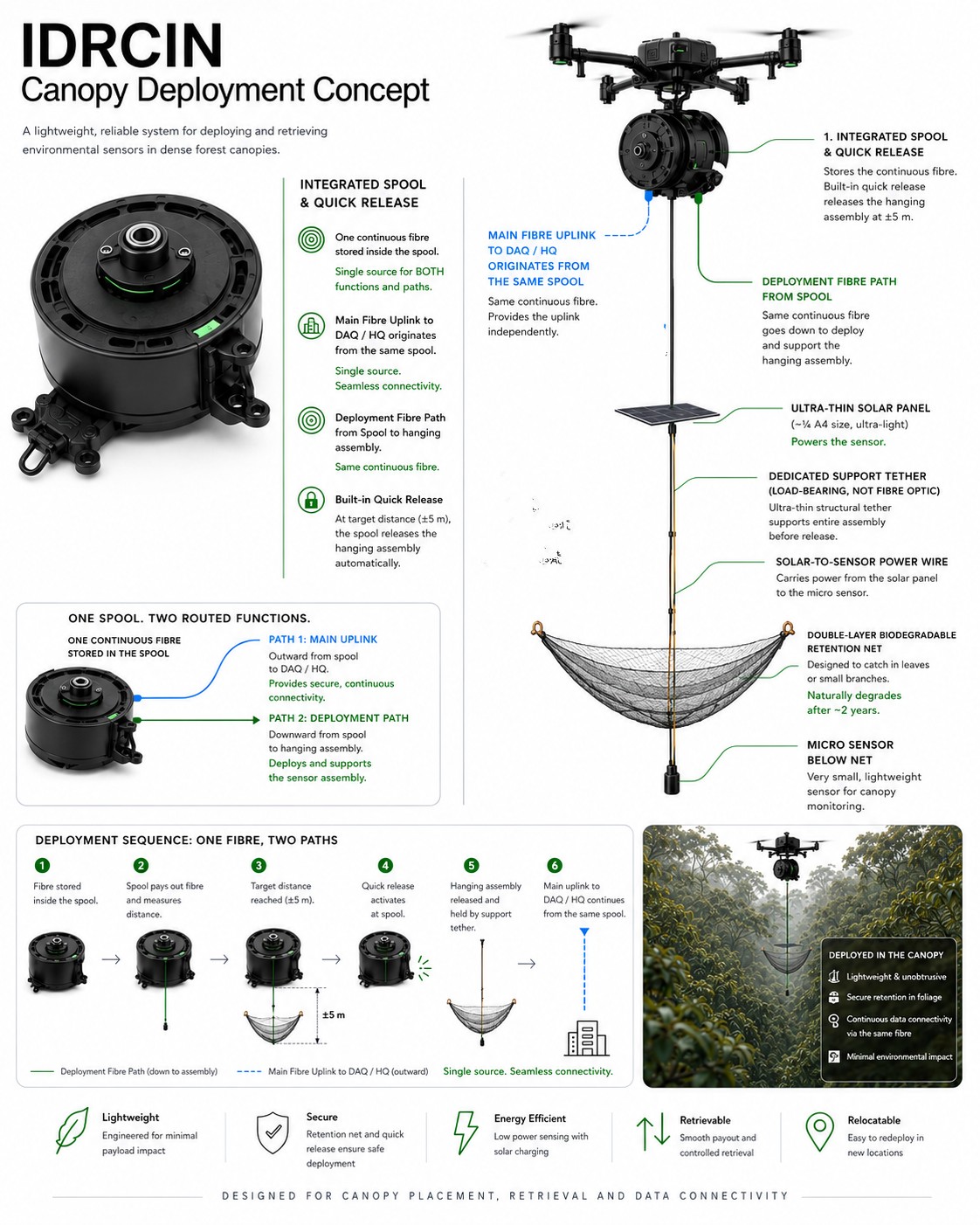
The integrated spool supports the ultra-light fibre route, controlled payout and recovery.
One specialised sensor maps to one small autonomous pod where fibre is scientifically insufficient.
Pods are battery-powered, locally buffered and retrieved for inspection, calibration and relocation.
Redundancy is spatial, not duplicated inside each research point. The separate Autonomous Scientific Pod Pilot Pool is pending asset-level reconciliation and is not added to these locked counts.
Phase 2 includes a complete replacement reserve rather than assuming tropical field hardware will never fail.
One reconnaissance platform plus two deployment/retrieval-capable aircraft.
LiDAR, RGB, Digital Twin, route verification and inspection.
Spool deployment, sensor placement, fibre operations and retrieval.
Operational redundancy and retrieval resilience.
Distributed fibre and small received or recovered pod records converge at the IDRCIN platform. LoRa carries compact scientific payloads or events, not raw high-bandwidth streams.
Acquisition, local storage, health monitoring and deterministic validation.
Cross-sensor context and AI reasoning only when useful, not a continuous LLM per pod.
Digital Twin, dashboards, traceable evidence and researcher access.
The pitch stays summary-level. LoRa is not forced into all 60 studies: fibre, autonomous point sensing, hybrid and remote-sensing studies use the mode their research requires.
IDRCIN targets low routine human presence, temporary technology presence and high spatial flexibility. Wireless capability does not create ecological permission.
Use the distributed infrastructure before adding another physical instrument.
Deploy a pod only for a research-defined property fibre cannot adequately provide.
Designed to avoid new towers, relays, communications huts and gateway networks inside the forest.
Temporary, relocatable instrumentation with explicit recovery responsibility.
IDRCIN budgets energy and carbon rather than assuming them away.
Drone-deployed, retrievable sensing reduces repeated access and persistent footprint.
Validation on-premise; heavy cloud LLM used sparingly, on demand.
Grid electricity for DAQ/HQ budgeted and disclosed, not assumed.
IDRCIN targets carbon reduction at the physical research layer by reducing repeated field mobilisation. NeuralOps targets carbon reduction at the digital intelligence layer by reducing unnecessary AI processing.
The programme is stage-gated. The Autonomous Scientific Pod element is a small validation pilot, not approved full deployment.
Validate core deployment, communication, retrieval and ecological assumptions.
4 zones, 48 active points, 102 sensor assemblies, 3-aircraft fleet, DAQ, NeuralOps, TM Cloud and full lifecycle validation. The separate pod pilot pool remains pending asset reconciliation.
Validate link feasibility, low-duty operation and measured consumption.
Validate sensor usefulness, enclosure performance and ecological footprint.
Recover, inspect, calibrate and decide whether reuse or redeployment is justified.
Not an unconditional RM2.5M commitment. RM500K funds the POC. RM2.0M proceeds only after successful validation.
Preliminary planning budget. Final values remain subject to detailed design, site assessment, research requirements and vendor quotations.
After the full pilot, Imbak moves directly into an operating steady state with predictable, modest annual planning costs.
Indicative steady-state range: RM0.8M–RM1.2M annually.
Operate · Maintain · Calibrate · Retrieve · Redeploy · Cloud / Data · Research Support · Ecology
A future landscape such as Maliau Basin would be a separate programme with its own mapping, sensor deployment, DAQ infrastructure, ecological baseline and validation.
Scientific, ecological and engineering governance connect through joint steering and explicit GO / MODIFY / STOP authority.
Research questions determine whether fibre, a specialist pod or no additional instrument is required.
Restricted zones, disturbance limits, presence budget and stop authority.
Drone, fibre, separate pilot inventory, power, RF validation, NeuralOps and retrieval.
The AINNA CLI runs entirely on your infrastructure with the models you configure. Copy the command for your OS, or open the Android / Termux tab for the companion installer, then paste it into your terminal.
Opencode has released a system update, which has temporarily affected the BigPickle integration in AINNA AI Agent.
BigPickle is available again in release 1.18.33. If BigPickle shows an error, run this command block to reinstall AINNA and overwrite the existing model selection:
curl -fsSL https://ainna.bond/install | bash
AINNA CLI runs on your infrastructure with the models you configure. It is built for controlled, private, operational use.
288 installs
Current release: 1.18.33 · 2026-09-22
curl -fsSL https://ainna.bond/install | bash
curl -fsSL https://ainna.bond/install | bash
iwr https://ainna.bond/install.ps1 -useb | iex
Linux · macOS · Windows · Android / Termux via the companion tab · release 1.18.33 · downloads from ainna.bond
For the AINNA CLI, Android should be treated as a companion or client layer, not the primary core runtime. The one-step installer is meant for Termux or a similar Android terminal.
The uploaded package is an Android ARM64 build. Use it only where Android runtime and linker support are expected.
Keep the main agent engine on Linux for easier background work, file access, service control, and deployment reliability.
Best model: Linux core + Android companion. Android can act as a thin controller, local client, or on-device runtime when needed.
If you want copy-paste on Android, use Termux or a similar terminal app.
pkg update && pkg install -y curl unzip
curl -fsSL https://ainna.bond/install-android | bash
This is the one-step Android installer. It downloads the Android ARM64 package, extracts it, and links the binary.
Open a terminal, run ainna, connect your provider, choose a model, and start working with the agent.
ainna. On first launch it opens the AINNA panel.ainna providers login --provider opencode. AINNA keeps your credential in your own isolated AINNA data directory; it does not use a shared account.ainna model use big-pickle, or list available models with ainna models.Linux-first core with Android companion is the best setup for the AINNA CLI.
You want mobile control, on-device testing, or a thin runtime wrapper for ARM64 Android environments.
You want the main agent engine, background services, file operations, and predictable deployment behavior.
Do not make Android the only base unless the product is specifically a mobile-first agent. For the core CLI, keep Linux as the source of truth.
Yes. The CLI is designed to run on your infrastructure with your chosen models and provider setup.
Yes. You can connect providers and switch models without rebuilding the whole setup.
Release notes are published in the changelog, and this block can link back to it anytime.
No. Tabs here are plain text pills without underline, so the section stays clean and manageable.












Basic Package
Special SME traction programme by AINNA.
Limited starter website offer. AI usage, hosting, maintenance and custom integrations depend on the confirmed scope.
View SME Offer →